SIO 210 Talley Topic 5: North Atlantic circulation and water
masses. Thermohaline forcing.
Lynne Talley, 1997
Back to SIO 210 index.
Reading,references and study questions for topic 5 - click here
Some online figures.
A large number of vertical CTD sections can be accessed using the
vertical section atlas for the Atlantic
.
North Atlantic meridional section at 35W
Potential Temperature,
Salinity,
Potential Density (0 dbar),
Potential Density (4000 dbar)
A reference is:
McCartney, M.S., 1992. Recirculating components to
the deep boundary current of the northern North
Atlantic. Prog. Oceanogr., 29, 283-383.
North Atlantic zonal section at 24N
These sections show conditions in the central subtropical gyre, showing
the cold, lower oxygen Antarctic Bottom Water west of the mid-Atlantic
ridge, the high oxygen North Atlantic Deep Water along the western
boundary with recirculation into the western basin, the high salinity
Mediterranean Water.
Potential Temperature,
Salinity,
Oxygen
Roemmich, D. and C. Wunsch, 1985. Two transatlantic
sections: meridional circulation and heat flux in the
subtropical North Atlantic Ocean, Deep-Sea Res., 32,
619-664.
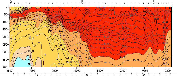
North Atlantic zonal section at 47N
These sections show conditions in the subpolar gyre, including the
cold deep western boundary current, the salinity minimum of the
Labrador Sea Water, and northward penetration of the Mediterranean
Water salinity maximum.
Potential Temperature,
Salinity,
Potential vorticity
Salinity as a function of density rather than depth
Outline
1. Large-scale circulation. Cartoon from Tomczak and Godfrey.
Reid (1994) adjusted steric height at the sea surface.
Worthington (1976) "two gyres" (Gulf Stream and North
Atlantic Current as two western boundary currents for the
subtropical gyre) with transports. Wind stress curl pattern showing
relation to the Gulf Stream and North Atlantic Current (McCartney,
1982).
2. Gulf Stream. Davis (1991) and Owens (1992) floats at
surface, 700 m and 2000 m.a Schmitz (1980) current meters at
55W. Showing penetration of Gulf Stream to bottom, meandering,
deep recirculations (westward flow on either side of the eastward
Gulf Stream).
3. Subduction. Central Water T/S relation. Creation of shallow
salinity maximum (Subtropical Underwater) in the southern subtropical
gyre through subduction (Worthington, 1976).
Salinity along 25W showing subducted high salinity
Wind stress curl pattern from McCartney with cartoon of subduction
in the northern subtropical gyre. Penetration of high salinity
along isopycnals from Sarmiento, and merging into Mediterranean
influence at greater depth.
4. Subtropical Mode Water (Eighteen Degree Water). Observations
from Challenger expedition in 1873 (Worthington, 1976). Relation
of formation and properties to Gulf Stream (Talley and Raymer, 1982).
Potential temperature section at 64W showing Eighteen Degree Water
from the
Atlantic vertical section atlas.
.
5. North Atlantic Deep Water formation. (For much more complete
Talley text, see Physical D reference listed in study questions.)
Five sources. Three
northern sources: Greenland Sea overflows into North Atlantic (deepest),
Labrador Sea (intermediate depth), Mediterranean outflow (shallowest
part). Two southern sources: Antarctic Intermediate Water and
Antarctic Bottom Water.
Mediterreanean outflow. (Ochoa and Bray; Zenk). Reid (1994) salinity
distribution at about 1000 m.
Subpolar Mode Water as antecedent for Norwegian Sea inflow and
Labrador Sea inflow (McCartney and Talley; McCartney).
Labrador Sea Water.
Deep convection in the Labrador Sea.
47N salinity section showing Labrador Sea Water.
Maps showing spreading through
North Atlantic subpolar regions and southward under the
Gulf Stream in the upper portion of the Deep Western Boundary Current.
(Talley and McCartney, 1982; Reid, 1994).
Norwegian-Greenland Sea. (Greenland/Iceland/Norwegian or GIN
Sea overflows). Greenland Sea deep convection region offshore
of ice edge (Morawitz et al., 1996). Outflow through Denmark Strait
along Greenland coast (Dickson and Brown, 1994.) Southward spread
in deeper part of DWBC (Jenkins, 1980). Deep recirculation gyres
(McCartney cartoon). Reid maps.
Antarctic Intermediate Water. Influence from
South Atlantic near same densities as Mediterranean Water.
Entry into N. Atlantic through western boundary current across
equator and zonal flows in the tropics.
Tracing northward using its high silica signal (Tsuchiya).
Antarctic Bottom Water. Reid (1994) deep maps showing
intrusion of bottommost waters into western North Atlantic,
crossing equator in a bottom western boundary current.
Transport diagrams for North Atlantic Deep Water formation, mainly
from Schmitz and McCartney.